GDD-50, Perennial Vintners (KWABAINB13), Bainbridge Island, WA
| Year: | 2008 | 2009 | 2010 | 2011 | 2012 | 2013 | 2014 | 2015 | 2016 | 2017 | 2018 | 2019 | 2020 | 2021 | 2022 | 2023 | 2024 | 2025 | 2026 |
| Total: | 1440 | 1735 | 1487 | 1453 | 1580 | 1881 | 2176 | 2184 | 2075 | 1984 | 2080 | 2002 | 2034 | 2087 | 2113 | 2169 | 1956 | 2124 | -- |
| YTD: | 0 | 0 | 0 | 0 | 0 | 0 | 0 | 0 | 0 | 0 | 0 | 0 | 0 | 0 | 0 | 0 | 0 | 0 | 0 |
Hover mouse over line to display datapoint, hover over legend to highlight series.
*MesoWest/BI (derated 14%, see below)
Overview
Perennial Vintners has tracked the Growing Degree Days Base 50 (GDD) since 2008. The data was acquired via Weather Underground from the MesoWest weather station at the WADOT ferry terminal in Eagle Harbor on Bainbridge Island. That station is only 3.7 miles from the vineyards, but it is next to Puget Sound, whereas the vineyards are 1 mile from the closest water with south facing slopes.
In 2012, Perennial Vintners installed a weather station, both to track GDD and to develop a model to limit spraying, since the closest WSU AgWeatherNet station is 11 miles away across Puget Sound by Lake Washington.
Due to the difference in location and microclimate, a comparison between the prior MesoWest and the current Perennial Vintners data needs to be established.
Analysis
For the 2012 GDD season, the MesoWest highs are only slightly below Perennial Vintners, but the Perennial Vintners lows are lower than MesoWest. This may be due to the marine influence 'leavening' the MesoWest temperature, whereas the open exposure away from the water at Perennial Vintners has somewhat higher highs and notably lower lows.
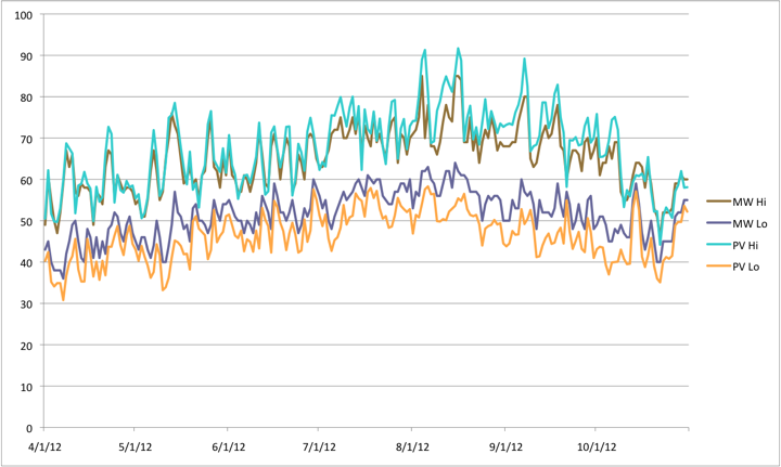
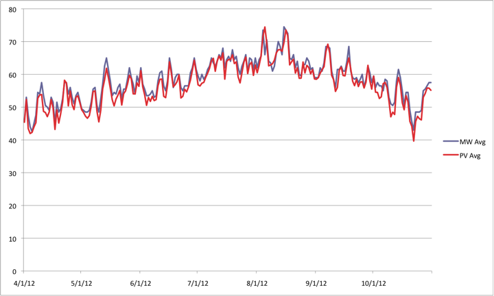
Since the lows at Perennial Vintners are more lower than the highs are higher compared to MesoWest, the average is also lower.
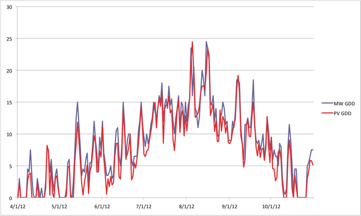
The daily GDD is also lower.
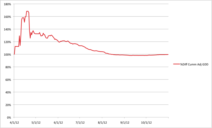
The cumulative GDD for Perennial Vintners as of October 31, 2012 was 1580, whereas the cumulative GDD at MesoWest was 1827. Therefore, MesoWest had 116% of the Perennial Vintners GDD, or conversely, Perennial Vintners had 86% of the GDD of MesoWest.
So - approximately - derating MesoWest data prior to 2012 by 14% should make it's GDD relate more closely to the new Perennial Vintners data.
Therefore the MesoWest data for 2008-2011 in the live chart at the top of this page has been divided by 1.14.
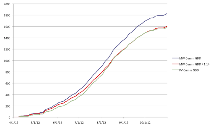
The following chart shows the ratio between the cumulative GDD for Perennial Vintners and the GDD divided by 1.14 for MesoWest.
Research & analysis by HawkFeather Web Design